I saved Verdun for last.
Pic 1 is the biggest cemetary I have ever seen - and that's just some of the French soldiers they could identify.
The main Verdun battlefield is a range of hills NE of Verdun. In 1914 the German border was (since 1871) not very far away. Verdun was defended by a ring of fortresses on the hills. The most famous being Fort Douamont & Fort Vaux. Fighting also extended down the range of hills to the east of Verdun and on the other side of the Meuse in the Argonne. The battle started in February 1916 and petered out in December 800,000 casualties later. Pic 2 is poster of a map of the battlefield.
After the 1914 stalemate, Verdun was in a salient in the French line. The great German attack on Verdun of 1916 started with an attack at the head of the salient. I've often wondered why they didn't attack the flanks to try to pincer it off. I think the reasons may have been:
1) Attacking the salient from the E required attacking the range of French hills from a plain - the build up and supply lines would have been in plain French view.
2) Attacking the salient down the west side of the Meuse was hampered by successive rows of hills (see Butt de Vauquois in an earlier post).
3) Attacking down the ridge from the N made it much easier to run supply lines out of French sight and the attacks were easier along the ridges rather than at them.
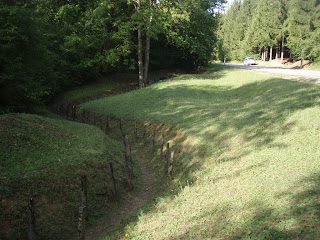
Pic 3 is a typical example of the shape of the ground.
Pic 4 is the remains of a reinforced communication trench.
In 1916, the hills were much less forested than now. Certainly the fields of fire from the forts would have been cleared. And once the artillery & MGs had been going for a while, the trees would have been stripped bare anyway. There were several villages in the area villages in the area surrounded by farmland, but they were all destroyed in the fighting. They were never rebuilt because of the dangers of UXB's, gas contamination, the decomposing bodies, and quite likely the ghosts of the dead. It is an eerie place, not where you would choose to live. The ground is now heavily forested, but even so the surface is completely hummocked by old shell holes and trench works.
The main features are well signposted and have interpretation signs in French, German & English, so it's easy to find your way and to appreciate the site. At Fort Douaumont you get an excellent Ipod guide with the price of admission. (E6.50 gets you into both Vaux & Douaumont).
As well as the main forts there are lesser ones all over the place. Stop the car & wander into the scrub anywhere & you find probably find pillboxes, trenches, gun emplacement, and always the shell holes.
Pic 5 is the top of Fort Vaux. Pic 6 is the French side of Fort Vaux - shot up by the French in taking it back. Pic 7 is inside Fort Vaux.
Pic 8 is the French side of Fort Douaumont. Pic 9 is the galcis of the fort.
Amazingly, before the German attacked the forts of Verdun had been partly decommisioned. The French high command having decided in their wisdom that because the Germans took the Belgian forts, such forts were obsolete. They had only just begun to undo the damage when the Germans attacked. When the Germans attacked Fort Douaumont, the advance guard of pioneers found a door, walked in and rounded up the small garison without a shot. It took untold rounds of heavy artillery and dead soldiers to get it back.
In some ways the Verdun Forts are not as good to see as the Maginot line. The Maginot Forts are pretty well as they were left in 1940. The Verdun Forts were generally repaired & upgunned in 1917 after the French took them back (the high command had realised the error of their ways re forts by then). They have also been extensively cleaned up and sanitised to make them safe for public access. But the overall effect of the Verdun battlefield is simply awesome in the true sense of the word.


No comments:
Post a Comment