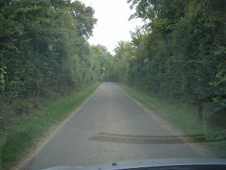
The country close to the beaches was usually open but it changed completely when I left the coastal strip. Much of the true bockage has been ripped out to widen roads, but enough remains to see what it was like. The terrain is rolling hills, sometimes quite steep, with a patchwork of hedged fields and woods. I've tried to take some representative photos to show what the ground is like. Some things struck me as wrong about our FOW terrain:
We tend to have small isolated hills about the same size as fields and patches of woods or villages - all on a flat surface. This doesn't happen in the bockage (and rarely anywhere else for that matter). Hills are rolling ridges much, much bigger in scale than woods, fields or villages.
I stayed overnight with my cousin at Saint-Pois between Avranches & Vire. The US came this way, but there was no significant battle there.
Next day I returned to Paris via Falaise.
To the east of Falaise, the terrain suddenly opened out into a big plain with wooded hills in the distance all around.
East of Falaise, about 5 K's short of Trun there was a memorial on a little rise with a view over the ground where the pocket was closed and very informative set of signboards.
These included boards showing the manoeuvres to here, then this excellent large scale map of the ground in front of you. Battlefield hunting doesn't get any easier than this.
This is the German's road home. The plain ends at Trun. The hill on th left is Hill 26s where the pocket was formally closed when the Canadians met the Poles.
This overlaps the previous pic & is to the right of it. This is the ground across which the Yanks, with it seems, Poles in the front, advanced (from right to left) to close the pocket.
On Hill 262, or Mont-Omel, there is a museum and a monument at the point where the pocket was closed.
There is a very cute M8 armoured car there.

And a very fine late model Sherman with 76mm gun & 7 armour.
And the view from the monument to the SW where the US came from is just brilliant. (Click to enlarge).
And finally, the piece de resistance of the whole trip - le Tiger de Vimoutiers. In the fighting to resist the closing of the gap this Tiger was abandoned by its crew when they ran out of diesel. It remained in place damaged by its crew, souvenier hunters and scrap merchants until the local Marie took charge of it and scrounged enough bits of Tiger from elsewhere to make it pretty well whole again.
It stands by the road looking across the valley towards the Canadians. I love this commander's eye view along that 88. I've seen Tigers in museums before, but this is the first time I've been able to climb all over one.
It's interesting to compare this pic with the one in front of the Sherman above. Fearsome as it is, the Tiger isn't actually any higher.


1 comment:
Fantastic pictures and very interesting observation about the terrain. Looks like bigger - table spanning - hills are now on my shopping list!
Post a Comment